
Volga Naddi

Volga, Europe ke sab se lamba naddi hae.[1] Russian me iske Волга bolaa jaawe hae , aur Tatar bhasa me İdel. Bahut log iske Russia ke national naddi maane hae. Ii Russia ke west me se bahe hae. Iske lambai ,690 km (2,293 miles) hae.
-
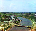 Rzev is the first town on the banks of the Volga. Photo from the early 20th century
 -
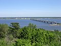 The Volga, near Ulyanovsk
 -
 Satellite image of the Volga
 -
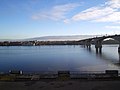 Volga in Yaroslavl


References
[badlo | source ke badlo]- ↑ "The Volga River". Rivers of Life. Center for Global Environmental Education - Hamline University Graduate School of Education. 2001. Archived from the original on 2008-10-17. Retrieved 2008-10-24.