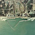
file:Fukushima I NPP 1975.jpg

Ii preview ke size: 600 × 600 pixels Duusra resolutions: 240 × 240 pixels | 480 × 480 pixels | 768 × 768 pixels | 1,024 × 1,024 pixels | 2,511 × 2,511 pixels.
Original file (2,511 × 2,511 pixel, file ke size: 1.15 MB, MIME type: image/jpeg)
File ke itihaas
File ke dekhe khatir, jaise uu time dekhe me lagat rahaa, date/time pe click karo.
| Din/Time | Chhota chapa | Lambai aur chaurai | Sadasya | Tiprrin | |
|---|---|---|---|---|---|
| abhi waala | 08:43, 24 Actobar 2017 |  | 2,511 × 2,511 (1.15 MB) | Togabi | Color adjustment. |
| 12:26, 4 Aprel 2011 |  | 2,511 × 2,511 (1.17 MB) | 84user | Reverted to version as of 09:18, 15 January 2011 please make a new image page for such a change | |
| 21:32, 2 Aprel 2011 |  | 2,511 × 2,496 (1.18 MB) | Hydrargyrum | lossless rotation 90 deg. left to place north at top (standard) and match Google Maps and other online mapping sites. | |
| 09:18, 15 Janwari 2011 |  | 2,511 × 2,511 (1.17 MB) | Qurren | == {{int:filedesc}} == {{Information |Description={{en|1=en:Fukushima I Nuclear Power Plant.}} {{ja|1=ja:福島第一原子力発電所。}} |Source=Japan Ministry of Land, Infrastructure and Transport. [http://w3land.mlit.go.jp/cgi-bin/WebGIS |
File ke kaise kaam me lawa gais hae
Niche ke panna kaam me laae hai ii file ke:
Global file usage
Ii aur duusra wiki ii file ke use kare hai:
- af.wikipedia.org pe upyog
- ar.wikipedia.org pe upyog
- ast.wikipedia.org pe upyog
- be-tarask.wikipedia.org pe upyog
- ca.wikipedia.org pe upyog
- ca.wikinews.org pe upyog
- cs.wikipedia.org pe upyog
- cv.wikipedia.org pe upyog
- da.wikipedia.org pe upyog
- de.wikipedia.org pe upyog
- en.wikipedia.org pe upyog
- en.wikinews.org pe upyog
- eo.wikipedia.org pe upyog
- es.wikipedia.org pe upyog
- et.wikipedia.org pe upyog
- fa.wikipedia.org pe upyog
- fr.wikipedia.org pe upyog
- fr.wikinews.org pe upyog
- Que s'est-il passé dans la centrale nucléaire de Fukushima Daiichi ?
- Accidents nucléaires de Fukushima : les évènements du 18 mars 2011
- Accidents nucléaires de Fukushima : les évènements du 22 mars 2011
- Accidents nucléaires de Fukushima : les évènements du 28 mars 2011
- Accidents nucléaires de Fukushima : des employés essayent de boucher la fuite d'eau radioactive
- Accidents nucléaires de Fukushima : la fuite d'eau radioactive colmatée
- he.wikipedia.org pe upyog
- hr.wikipedia.org pe upyog
- hu.wikipedia.org pe upyog
- id.wikipedia.org pe upyog
- it.wikipedia.org pe upyog
- ja.wikipedia.org pe upyog
- jv.wikipedia.org pe upyog
- ml.wikipedia.org pe upyog
- mr.wikipedia.org pe upyog
- ms.wikipedia.org pe upyog
- nl.wikipedia.org pe upyog
- pl.wikipedia.org pe upyog
- ro.wikipedia.org pe upyog
Ii file ke more global usage kedekho.


