
file:Barents Sea map.png
Ii preview ke size: 657 × 600 pixels Duusra resolutions: 263 × 240 pixels | 526 × 480 pixels | 841 × 768 pixels | 1,187 × 1,084 pixels.
Original file (1,187 × 1,084 pixel, file ke size: 654 KB, MIME type: image/png)
Sanchhipt me
| Baare me |
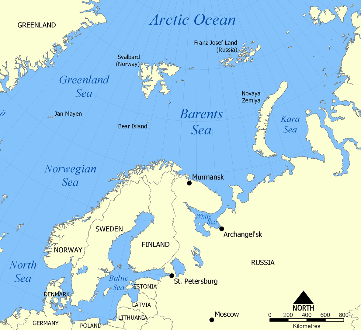
English: The location of the Barents Sea north of Russia and Norway, and the surrounding seas and islands. Also includes political borders with their corresponding nation-states listed. |
| Taarik | |
| Source | Aapan kaam |
| Likhe waala | NormanEinstein |
| Other versions |
[]
|


Licence ke baare me
I, the copyright holder of this work, hereby publish it under the following licenses:

|
Ijaajat dewa jaae hae ii document ke copy, distribute aur kare ke,under the terms of the GNU Free Documentation License, Version 1.2 or any later version published by the Free Software Foundation; with no Invariant Sections, no Front-Cover Texts, and no Back-Cover Texts. A copy of the license is included in the section entitled GNU Free Documentation License. |
| ii file ke Creative Commons Attribution-Share Alike 3.0 Unported license ke niche licence karaa gais hai. | ||
| ||
| This licensing tag was added to this file as part of the GFDL licensing update. |
Aap aapan pasand ke licence ke chune saktaa hai.
File ke itihaas
File ke dekhe khatir, jaise uu time dekhe me lagat rahaa, date/time pe click karo.
| Din/Time | Chhota chapa | Lambai aur chaurai | Sadasya | Tiprrin | |
|---|---|---|---|---|---|
| abhi waala | 20:52, 29 Maach 2012 | | 1,187 × 1,084 (654 KB) | Ras67 | cropped |
| 06:11, 5 Farwari 2006 |  | 1,200 × 1,098 (680 KB) | Berkut~commonswiki | pngout-ed (13% file size reduction) | |
| 16:40, 25 Navambar 2005 |  | 1,200 × 1,098 (781 KB) | NormanEinstein | This map shows the location of the Barents Sea north of Russia and Norway, and the surrounding seas and islands. Created by NormanEinstein, November 25, 2005. {{GFDL-self}} Category:Maps of seas |
File ke kaise kaam me lawa gais hae
Niche ke panna kaam me laae hai ii file ke:
Global file usage
Ii aur duusra wiki ii file ke use kare hai:
- af.wikipedia.org pe upyog
- ar.wikipedia.org pe upyog
- arz.wikipedia.org pe upyog
- ast.wikipedia.org pe upyog
- azb.wikipedia.org pe upyog
- bcl.wikipedia.org pe upyog
- be-tarask.wikipedia.org pe upyog
- bg.wikipedia.org pe upyog
- bn.wikipedia.org pe upyog
- bs.wikipedia.org pe upyog
- ca.wikipedia.org pe upyog
- cs.wikipedia.org pe upyog
- cs.wikinews.org pe upyog
- da.wikipedia.org pe upyog
- de.wiktionary.org pe upyog
- el.wikipedia.org pe upyog
- en.wikipedia.org pe upyog
- Barents Sea
- User:NormanEinstein/gallery
- Keith Jessop
- Convoy PQ 1
- Convoy PQ 2
- Convoy PQ 18
- Gyda Peninsula
- Fishing industry in Russia
- Operation Fritham
- List of Russian explorers
- Convoy PQ 12
- Convoy PQ 11
- Convoy PQ 9/10
- Convoy PQ 8
- Arctic naval operations of World War II
- Convoy QP 14
- List of oil and gas fields of the Barents Sea
- Operation Orator
- Operation Gearbox
- Operation Gearbox II
- Convoy QP 1
- Atlantification of the Arctic
- en.wikisource.org pe upyog
- en.wiktionary.org pe upyog
- eo.wikipedia.org pe upyog
- es.wikipedia.org pe upyog
- eu.wikipedia.org pe upyog
- fa.wikipedia.org pe upyog
- fi.wikipedia.org pe upyog
- fo.wikipedia.org pe upyog
Ii file ke more global usage kedekho.