file:Geographic distribution of Bengali language.png

Page contents not supported in other languages.
Wikipedia se

Original file(2,806 × 2,080 pixel, file ke size: 1.36 MB, MIME type: image/png)

Ii file Wikimedia Commons se aais hai aur duusra projects me bhi kaam me lawa jaae sake hai. Iske baare me aur jaankari file description page ke niche dekhawa jaae hai.

Sanchhipt me

Baare me
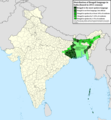
Ελληνικά: Γεωγραφική κατανομή της Βεγγαλικής Γλώσσας ανά επαρχία της Ινδίας και στο Μπανγκλαντές, τα χρώματα στις επαρχίες ποικίλουν ανάλογα με το ποσοστό ομιλητών (δεδομένα απογραφής 2011). Παράγωγο του αρχείου India district map (de-facto).svg.
English: Geographic distribution of Bengali language in India and Bangladesh. The map covers each district of India and the five shades of green show the percentage of Bengali language speakers in each district. Source: Indian census 2011. Feel free to enrich the map with data for more Indian districts, or fix any mistakes. Derivative of the file India district map (de-facto).svg.
Taarik
Source Aapan kaam
Likhe waala NikosLikomitros

Licence ke baare me

I, the copyright holder of this work, hereby publish it under the following license:
w:en:Creative Commons
attribution share alike
This file is licensed under the Creative Commons Attribution-Share Alike 4.0 International license.
You are free:
  • share kare ke khaatir – to copy, distribute and transmit the work
  • to remix – to adapt the work
II condition ke niiche:
  • attribution – Aap ke thiik credit de ke chaahi, licence pe jorr de ke chaahi, aur badlao ke dekhae ke chaahi. Aap iske koi reasonable manner me kare saktaa hai lekin aise nai ki lage ki licensor aap ke, nai to aap ke kaam ke endorse kre hai
  • share alike – Agar aap milaata hai, badaltaa hai, nai to material pe jorrtaa hai, tab aap ke aapan yogdaan ke same or compatible license ke niche baate kare kae chaaahi.

Captions

Add a one-line explanation of what this file represents
Geographic distribution of Bengali language in India and Bangladesh. The map covers each district of India and the five shades of green show the percentage of Bengali language speakers in each district. Source: Indian census 2011.

Items portrayed in this file

depicts English

copyrighted English

inception English

26 Juun 2022

media type English

image/png

File ke itihaas

File ke dekhe khatir, jaise uu time dekhe me lagat rahaa, date/time pe click karo.

Din/TimeChhota chapaLambai aur chauraiSadasyaTiprrin
abhi waala15:05, 2 Julai 202215:05, 2 Julai 2022 waala version ke chhota chapa2,806 × 2,080 (1.36 MB)NikosLikomitrosA few districts of Arunachal Pradesh have a notable Bengali presence above of 1%, probably part of the Indian efforts to increase its presence in the region.
16:55, 1 Julai 202216:55, 1 Julai 2022 waala version ke chhota chapa2,806 × 2,080 (1.36 MB)NikosLikomitrosTwo extra fixes.
16:53, 1 Julai 202216:53, 1 Julai 2022 waala version ke chhota chapa2,806 × 2,080 (1.36 MB)NikosLikomitrosMinor fixes.
16:44, 1 Julai 202216:44, 1 Julai 2022 waala version ke chhota chapa2,806 × 2,080 (1.36 MB)NikosLikomitrosNow, this map covers all districts of India. Includes also extra information and a new colour key. The basemap is from Distribution_of_Jats_in_South_Asia.png.
21:09, 26 Juun 202221:09, 26 Juun 2022 waala version ke chhota chapa1,902 × 2,048 (1,002 KB)NikosLikomitrosUploaded own work with UploadWizard

Ii file ke koi panna kaam me nai laae hai.

Global file usage

Ii aur duusra wiki ii file ke use kare hai:

Metadata