
file:Volgarivermap.png
Aur achchha resolution nai hai.
Volgarivermap.png (500 × 500 pixel, file ke size: 155 KB, MIME type: image/png)

|
This map image could be re-created using vector graphics as an SVG file. This has several advantages; see Commons:Media for cleanup for more information. If an SVG form of this image is available, please upload it and afterwards replace this template with
{{vector version available|new image name}}.
It is recommended to name the SVG file “Volgarivermap.svg”—then the template Vector version available (or Vva) does not need the new image name parameter. |
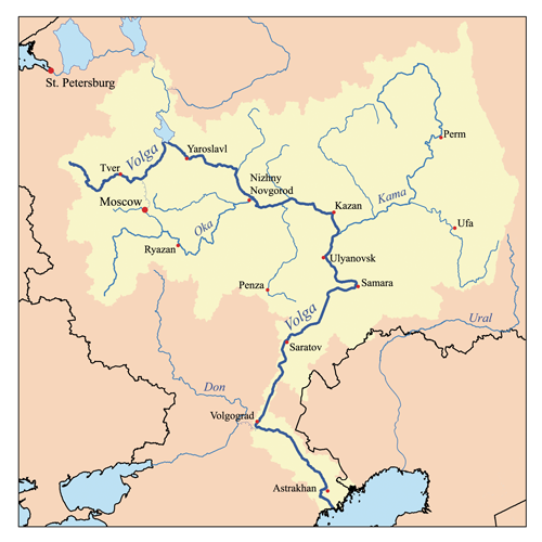
This is a map of the Volga River system. I, Karl Musser, created it based on USGS data.
I, the copyright holder of this work, hereby publish it under the following license:
This file is licensed under the Creative Commons Attribution-Share Alike 2.5 Generic license.
- You are free:
- share kare ke khaatir – to copy, distribute and transmit the work
- to remix – to adapt the work
- II condition ke niiche:
- attribution – Aap ke thiik credit de ke chaahi, licence pe jorr de ke chaahi, aur badlao ke dekhae ke chaahi. Aap iske koi reasonable manner me kare saktaa hai lekin aise nai ki lage ki licensor aap ke, nai to aap ke kaam ke endorse kre hai
- share alike – Agar aap milaata hai, badaltaa hai, nai to material pe jorrtaa hai, tab aap ke aapan yogdaan ke same or compatible license ke niche baate kare kae chaaahi.
derivative works
Derivative works of this file:
File ke itihaas
File ke dekhe khatir, jaise uu time dekhe me lagat rahaa, date/time pe click karo.
| Din/Time | Chhota chapa | Lambai aur chaurai | Sadasya | Tiprrin | |
|---|---|---|---|---|---|
| abhi waala | 17:06, 23 Julai 2007 | | 500 × 500 (155 KB) | Kmusser | Ural river fix |
| 14:50, 17 Actobar 2006 |  | 500 × 500 (40 KB) | Kmusser | ||
| 20:15, 31 August 2006 |  | 500 × 500 (126 KB) | Kmusser | This is a map of the Volga River system. I, Karl Musser, created it based on USGS data. {{self|cc-by-sa-2.5}} Category:Maps of rivers |
File ke kaise kaam me lawa gais hae
Niche ke panna kaam me laae hai ii file ke:
Global file usage
Ii aur duusra wiki ii file ke use kare hai:
- af.wikipedia.org pe upyog
- als.wikipedia.org pe upyog
- ang.wikipedia.org pe upyog
- an.wikipedia.org pe upyog
- ar.wikipedia.org pe upyog
- arz.wikipedia.org pe upyog
- ast.wikipedia.org pe upyog
- as.wikipedia.org pe upyog
- avk.wikipedia.org pe upyog
- Tsna (kuksa ke Mokca)
- Volga (kuksa)
- Teza:VolgaBost
- Samara (kuksa)
- Borovka (kuksa)
- Tok (kuksa)
- Bolcoy Uran (kuksa)
- Mali Uran (kuksa)
- Bolcoy Kinel (kuksa)
- Buzuluk ke Volga (kuksa)
- Bolcoy Irgiz (kuksa)
- Kamelik (kuksa)
- Bolcaya Tcalikla (kuksa)
- Bolcoy Kucum (kuksa)
- Sura (kuksa)
- Alatir (kuksa)
- Baric (kuksa)
- Teza:SuraKuksa
- Teza:SamaraKuksa
- Teza:BolcoyIrgizKuksa
- Kadada (kuksa)
- Uza (kuksa)
- Ugra (kuksa ke Sura)
- Pyana (kuksa)
- Bezdna (kuksa)
- Inza (kuksa)
- Kirya (kuksa)
- Insar (kuksa)
- Oka (kuksa)
- Teza:OkaKuksa
- Mokca (kuksa)
Ii file ke more global usage kedekho.