
file:The British Empire1.png

Ii preview ke size: 800 × 406 pixels Duusra resolutions: 320 × 162 pixels | 640 × 325 pixels | 1,024 × 520 pixels | 1,280 × 650 pixels | 2,754 × 1,398 pixels.
Original file (2,754 × 1,398 pixel, file ke size: 145 KB, MIME type: image/png)
Sanchhipt me
| Baare me |
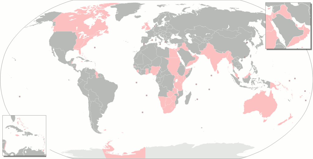
Deutsch: Gebiete, die zur einen oder anderen Zeit Teil des britischen Weltreiches waren.
English: The territories that were at one time or another part of the British Empire.
Français : Territoires ayant fait partie de l'Empire britanique.
Русский: Территории, когда-либо бывшие частью Британской империи.
Українська: Території, які колись були частиною Британської імперії. |
| Taarik | |
| Source | Aapan kaam |
| Likhe waala | Gd21091993 |
| Other versions |
The British Empire.png The British Empire (including Crown Dependencies, Crown Colonies-Overseas Territories, Protectorates, Military Administrations).png Map of British India.png British Empire Map (Chinese).svg The British Empire Anachronous.png forked on enwiki |
.png)
.svg)
Licence ke baare me
| I, the copyright holder of this work, release this work into the public domain. This applies worldwide. In some countries this may not be legally possible; if so: I grant anyone the right to use this work for any purpose, without any conditions, unless such conditions are required by law. |
File ke itihaas
File ke dekhe khatir, jaise uu time dekhe me lagat rahaa, date/time pe click karo.
| Din/Time | Chhota chapa | Lambai aur chaurai | Sadasya | Tiprrin | |
|---|---|---|---|---|---|
| abhi waala | 23:48, 7 Navambar 2021 | | 2,754 × 1,398 (145 KB) | Randomastwritter | somali galbeed |
| 00:51, 31 Actobar 2021 |  | 2,754 × 1,398 (144 KB) | Randomastwritter | juba | |
| 00:49, 31 Actobar 2021 |  | 2,754 × 1,400 (526 KB) | Randomastwritter | jubaland | |
| 23:20, 3 Farwari 2018 |  | 2,754 × 1,398 (144 KB) | Maphobbyist | Upload | |
| 10:42, 27 Janwari 2018 |  | 2,754 × 1,398 (144 KB) | Maphobbyist | Added Weihei, Heligoland, the Mosquito Coast, Afghanistan which were under some form of British rule. Colored Chatham Islands of New Zealand and the southeastern islands of Papua New Guinea in pink. | |
| 07:45, 16 Farwari 2013 |  | 2,753 × 1,400 (65 KB) | JohnnyMrNinja | remove unused alpha, indexed colors and increased compression | |
| 19:50, 2 Mai 2010 |  | 2,753 × 1,400 (477 KB) | Gd21091993 | {{Information |Description={{fr|1=Toute les possessions qui on un jour fait partie de l'empire britanique}} |Source={{own}} |Author=Gd21091993 |Date=02/05/2010 |Permission= |other_versions= }} |
File ke kaise kaam me lawa gais hae
Niche ke panna kaam me laae hai ii file ke:
Global file usage
Ii aur duusra wiki ii file ke use kare hai:
- an.wikipedia.org pe upyog
- br.wikipedia.org pe upyog
- bs.wikipedia.org pe upyog
- da.wikipedia.org pe upyog
- eo.wikipedia.org pe upyog
- es.wikipedia.org pe upyog
- eu.wikipedia.org pe upyog
- fa.wikipedia.org pe upyog
- fr.wikipedia.org pe upyog
- gl.wikipedia.org pe upyog
- hak.wikipedia.org pe upyog
- hr.wikipedia.org pe upyog
- hu.wikipedia.org pe upyog
- hu.wiktionary.org pe upyog
- is.wikipedia.org pe upyog
- it.wikipedia.org pe upyog
- ne.wikipedia.org pe upyog
- nl.wikipedia.org pe upyog
- ro.wikipedia.org pe upyog
- ru.wiktionary.org pe upyog
- sah.wikipedia.org pe upyog
- sh.wikipedia.org pe upyog
- xh.wikipedia.org pe upyog