
file:NepalAchhamDistrictmap.png

Original file (2,479 × 3,508 pixel, file ke size: 339 KB, MIME type: image/png)
| Baare me |
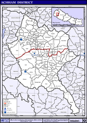
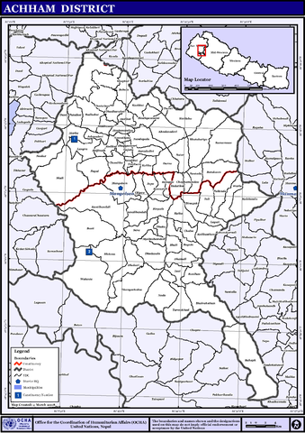
English: Map displaying Village Development Committees in Achham District, Nepal |
|||
| Taarik | ||||
| Source | http://www.un.org.np/maps/district-maps/far-western/Achham.pdf | |||
| Likhe waala | United Nations | |||
| Adhikaar (Ii file ke fir se kaam me laawa jaae hai) |
|

File ke itihaas
File ke dekhe khatir, jaise uu time dekhe me lagat rahaa, date/time pe click karo.
| Din/Time | Chhota chapa | Lambai aur chaurai | Sadasya | Tiprrin | |
|---|---|---|---|---|---|
| abhi waala | 01:24, 6 Navambar 2008 | | 2,479 × 3,508 (339 KB) | Sadalmelik | {{Information |Description={{en|1=Map displaying Village Development Committees in Achham District, Nepal}} |Source=http://www.un.org.np/maps/district-maps/far-western/Achham.pdf |Date=March 4, 2008 |Author=United Nations |Permission={{PD-UN}} |other_ |
File ke kaise kaam me lawa gais hae
Niche ke panna kaam me laae hai ii file ke:
Global file usage
Ii aur duusra wiki ii file ke use kare hai:
- bpy.wikipedia.org pe upyog
- de.wikipedia.org pe upyog
- en.wikipedia.org pe upyog
- fi.wikipedia.org pe upyog
- hi.wikipedia.org pe upyog
- ग्राम विकास समिति
- साँचा:अछाम जिला
- ऋषिदह
- कालागाउँ
- कालिका, अछाम
- कालिकास्थान, अछाम
- कालेगाँडा
- कुइका
- कुशकोट
- खप्तड
- गजरा गाँव
- घोडासैण
- चाँफामाण्डौ
- चाल्सा
- छतरा
- जनालीकोट
- टिमिलसैन
- ठांटी
- ढकारी
- ढाकु
- ढुंगाचाल्ना
- ढुडारुकोट
- तडीगैरा
- तुर्माखाँद
- तोली, अछाम
- तोसी
- दर्ना
- दुनी
- देविस्थान
- धमाली
- नंदेगडा
- नाडा
- पाइल
- पातलकोट
- पुलेतोला
- बाबला
- बयाला
- बर्दादेबी
- बलाँता
- बस्ती, अछाम
- बाटुलासैन
- बान्नातोली
- बारला
- बिनायक
- बिन्ध्यावासीनी, अछाम
- बिरपथ
Ii file ke more global usage kedekho.