
file:India-map-en.svg

Size of this PNG preview of this SVG file: 514 × 600 pixels. Duusra resolutions: 206 × 240 pixels | 411 × 480 pixels | 658 × 768 pixels | 877 × 1,024 pixels | 1,755 × 2,048 pixels | 1,519 × 1,773 pixels.
Original file (SVG file, naam kare ke khatir 1,519 × 1,773 pixels, file size: 277 KB)
Ok ther are not anyone
Sanchhipt me
| Baare me |
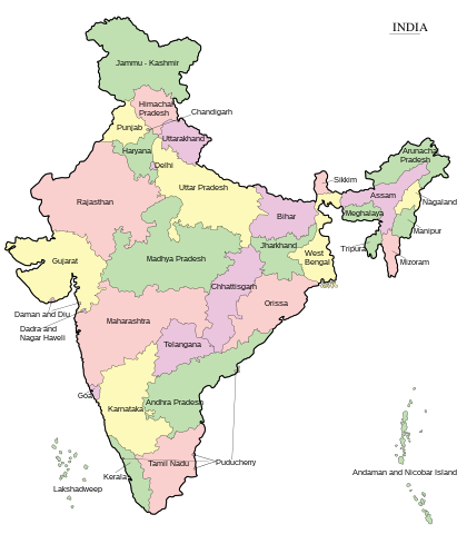
English: Map of India - states and union territories marked मराठी: भारताचा नकाशा हिन्दी : भारत का मानचित्र - राज्य और केंद्रशासित प्रदेश चिह्नित हैं বাংলা : ভারত দেশের মানচিত্র ਪੰਜਾਬੀ : ਭਾਰਤ ਦਾ ਨਕਸ਼ਾ ગુજરાતી : ભારતનો નકશો : રાજ્ય અને કેન્દ્રશાસિત પ્રદેશો ଓଡ଼ିଆ : ଭାରତ ମାନଚିତ୍ର தமிழ் : இந்தியாவின் வரைபடம் - மாநிலங்கள் மற்றும் யூனியன் பிரதேசங்கள் குறிக்கப்பட்டுள்ளன ಕನ್ನಡ : ಭಾರತದ ಭೂಪಟ മലയാളം : ഇന്ത്യയുടെ ഭൂപടം - സംസ്ഥാനങ്ങളും കേന്ദ്രഭരണപ്രദേശങ്ങളും അടയാളപ്പെടുത്തിയിരിക്കുന്നു اردو : بھارت کا نقشہ |
||
| Taarik | |||
| Source | Transferred from ml.wikipedia to Commons. | ||
| Likhe waala | Rajeshodayanchal at Malayalam Wikipedia. | ||
| Other versions |
[]
|


|
This SVG file contains embedded text that can be translated into your language, using any capable SVG editor, text editor or the SVG Translate tool. For more information see: About translating SVG files. |
Licence ke baare me
This media file is uploaded with Malayalam loves Wikimedia event.
|
Rajeshodayanchal at Malayalam Wikipedia, the copyright holder of this work, hereby publishes it under the following license:
ii file ke Creative Commons Attribution-Share Alike 3.0 Unported license ke niche licence karaa gais hai.
Attribution: Rajeshodayanchal at Malayalam Wikipedia
- You are free:
- share kare ke khaatir – to copy, distribute and transmit the work
- to remix – to adapt the work
- II condition ke niiche:
- attribution – Aap ke thiik credit de ke chaahi, licence pe jorr de ke chaahi, aur badlao ke dekhae ke chaahi. Aap iske koi reasonable manner me kare saktaa hai lekin aise nai ki lage ki licensor aap ke, nai to aap ke kaam ke endorse kre hai
- share alike – Agar aap milaata hai, badaltaa hai, nai to material pe jorrtaa hai, tab aap ke aapan yogdaan ke same or compatible license ke niche baate kare kae chaaahi.
Original upload log
This file was originally uploaded at ml.wikipedia as India-map-en.svg, before it was transfered to Commons.
Upload date | User | Bytes | Dimensions | Comment
- 4/10/2011 10:29:58 AM | Rajeshodayanchal | 277070 (bytes) | 1519×1773 | വിട്ടുപോയ കേന്ദ്രഭരണപ്രദേശങ്ങൾ കൂട്ടിച്ചേർക്കുന്നു
- 4/10/2011 2:28:09 AM | Rajeshodayanchal | 254531 (bytes) | 1519×1773 | {{വിവരങ്ങൾ |വിവരണം = ഇന്ത്യയുടെ ഭൂപടം - സംസ്ഥാനങ്ങളും കേന്ദ്രഭരണപ്രദേശങ്ങളും അടയാളപ്പെടുത്തി�
File ke itihaas
File ke dekhe khatir, jaise uu time dekhe me lagat rahaa, date/time pe click karo.
| Din/Time | Chhota chapa | Lambai aur chaurai | Sadasya | Tiprrin | |
|---|---|---|---|---|---|
| abhi waala | 07:55, 7 Juun 2017 | | 1,519 × 1,773 (277 KB) | Rajeshodayanchal | Updated the map with a new state Telangana |
| 13:32, 10 Aprel 2011 |  | 1,519 × 1,773 (271 KB) | Sreejithk2000 |
File ke kaise kaam me lawa gais hae
Niche ke 2 sab panna kaam me laae hai ii file ke:
Global file usage
Ii aur duusra wiki ii file ke use kare hai:
- af.wikipedia.org pe upyog
- bcl.wikipedia.org pe upyog
- bh.wikipedia.org pe upyog
- blk.wikipedia.org pe upyog
- bn.wikipedia.org pe upyog
- ca.wikipedia.org pe upyog
- de.wikipedia.org pe upyog
- dty.wikipedia.org pe upyog
- dv.wikipedia.org pe upyog
- en.wikipedia.org pe upyog
- es.wikipedia.org pe upyog
- fo.wikipedia.org pe upyog
- fr.wikipedia.org pe upyog
- gom.wikipedia.org pe upyog
- gu.wikipedia.org pe upyog
- he.wikipedia.org pe upyog
- hi.wikipedia.org pe upyog
- ilo.wikipedia.org pe upyog
- ja.wikipedia.org pe upyog
- ka.wikipedia.org pe upyog
- km.wikipedia.org pe upyog
- kn.wikipedia.org pe upyog
- mai.wikipedia.org pe upyog
Ii file ke more global usage kedekho.