
file:Assam locator map.svg

Size of this PNG preview of this SVG file: 734 × 600 pixels. Duusra resolutions: 294 × 240 pixels | 587 × 480 pixels | 940 × 768 pixels | 1,253 × 1,024 pixels | 2,506 × 2,048 pixels | 2,393 × 1,956 pixels.
Original file (SVG file, naam kare ke khatir 2,393 × 1,956 pixels, file size: 264 KB)
| Title |
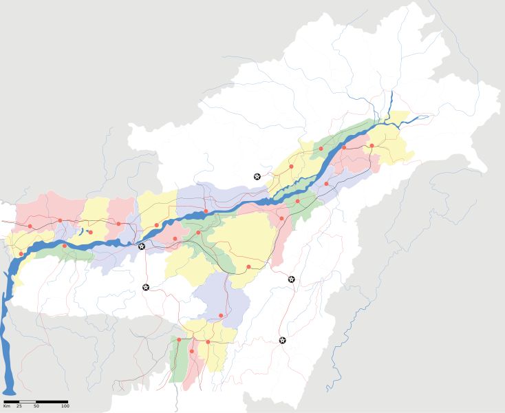
Assam locator Map |
||
| Description |
Map of w:Assam with road and rail lines. Coordinates: top=29.49, bottom=23.74, left=89.61, right=97.52. অসমীয়া: ৰেলপথ, যাত্ৰাপথ সমন্বিতে অসমৰ মানচিত্ৰ, স্থানাংক: ওপৰ=২৯.৪৯, তল=২৩.৭৪, বাও=৮৯.৬১, সো=৯৭.৫২। |
||
| Taarik | |||
| Source |
Aapan kaam |
||
| Creator |
|
||
| Adhikaar (Ii file ke fir se kaam me laawa jaae hai) |
I, the copyright holder of this work, hereby publish it under the following license: ii file ke Creative Commons Attribution-Share Alike 3.0 Unported license ke niche licence karaa gais hai.
|
||
| Geotemporal data | |||
| Date depicted | second half of 20 century aur 21 century | ||
| Georeferencing | If inappropriate please set warp_status = skip to hide. | ||
| Archival data | |||
| Notes | Part of WikiProject India Maps | ||
File ke itihaas
File ke dekhe khatir, jaise uu time dekhe me lagat rahaa, date/time pe click karo.
| Din/Time | Chhota chapa | Lambai aur chaurai | Sadasya | Tiprrin | |
|---|---|---|---|---|---|
| abhi waala | 18:53, 16 Aprel 2007 | | 2,393 × 1,956 (264 KB) | Planemad | |
| 18:36, 15 Aprel 2007 |  | 2,393 × 1,956 (215 KB) | Planemad | ||
| 17:20, 13 Aprel 2007 |  | 2,393 × 1,956 (206 KB) | Planemad | colored | |
| 16:56, 13 Aprel 2007 |  | 2,393 × 1,956 (216 KB) | Planemad | crop fix | |
| 16:55, 13 Aprel 2007 |  | 1,591 × 1,975 (216 KB) | Planemad | {{WikiProject_India_Maps |Title=Assam locator Map |Description=Map of w:Assam with road and rail lines |Source= [http://www.iitg.ernet.in/rcilts/assam_political.jpg IIT Guwahati - Assam Political map] |Date=April 2007 |Author=w:user:Planemad }} [ |
File ke kaise kaam me lawa gais hae
Niche ke panna kaam me laae hai ii file ke:
Global file usage
Ii aur duusra wiki ii file ke use kare hai:
- ar.wikipedia.org pe upyog
- as.wikipedia.org pe upyog
- তেজপুৰ
- শিৱসাগৰ
- বৰপেটা
- যোৰহাট
- উত্তৰ লখিমপুৰ
- কামাখ্যা মন্দিৰ
- সদস্য:Anshuman.jrt/নলবাৰী
- সদস্য:Anshuman.jrt/শিলচৰ
- মাধৱ থান
- শিৱসাগৰৰ শিৱদৌল
- আউনীআটী সত্ৰ
- গহপুৰ
- শ্ৰী শ্ৰী বটদ্ৰৱা থান
- ঢেকীয়াখোৱা বৰনামঘৰ
- সাঁচ:Location map India Assam
- মহাভৈৰৱ মন্দিৰ
- সদস্য:Psneog/infobox mandir
- সদস্য:Vssun/test
- বিশ্বনাথ চাৰিআলি
- তিনিচুকীয়া
- নগাঁও
- বঙাইগাঁও
- ঢকুৱাখনা
- নাৰায়ণপুৰ
- ৰঙিয়া
- পাঠশালা
- নেঘেৰিটিং শিৱদৌল
- বদলা পদ্ম আতা সত্ৰ
- মাঘনোৱা দ’ল
- কাজিৰঙা ৰাষ্ট্ৰীয় উদ্যান
- বৰদৈবাম বিলমুখ পক্ষী উদ্যান
- বিহপুৰীয়া (নগৰ)
- কোকৰাঝাৰ
- কৰিমগঞ্জ
- হাৰিভাংগা
- সোণাৰি
- দ'দান থান
- কমাৰকুছি থান
- কৈহাটী
- মাণিকপুৰ
- পবিতৰা অভয়াৰণ্য
- মঙলদৈ
- মানস ৰাষ্ট্ৰীয় উদ্যান
- নামৰূপ
- জাতিংগা
- গুপ্তেশ্বৰ দেৱালয়
- শ্ৰী শ্ৰী আঠখেলীয়া নামঘৰ
- হোলোঙাপাৰ গিবন অভয়াৰণ্য
- গৰমপানী অভয়াৰণ্য
Ii file ke more global usage kedekho.