
file:Satellite image of Hokkaido, Japan in May 2001.jpg

Ii preview ke size: 450 × 600 pixels Duusra resolutions: 180 × 240 pixels | 360 × 480 pixels | 576 × 768 pixels | 768 × 1,024 pixels | 2,400 × 3,200 pixels.
Original file (2,400 × 3,200 pixel, file ke size: 466 KB, MIME type: image/jpeg)
Sanchhipt me
| Baare me |
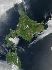
English: Satellite image of Hokkaido, Japan in May 2001. Taken from NASA's Visible Earth http://visibleearth.nasa.gov/view_rec.php?id=2060. This MODIS true-color image shows Hokkaido, Japan, at the top, and the northern tip of the island off Honshu at the bottom. Русский: Спутниковый снимок Хоккайдо (спутник Терра, NASA MODIS; май 2001 года) |
| Taarik | |
| Source | NASA |
| Likhe waala | NASA |
Licence ke baare me
| This file is in the public domain in the United States because it was solely created by NASA. NASA copyright policy states that "NASA material is not protected by copyright unless noted". (See Template:PD-USGov, NASA copyright policy page or JPL Image Use Policy.) | ||
 |
Warnings:
|
derivative works
Derivative works of this file: Akan volcano meakan-dake hokkaido japan space shot.jpg
| Annotations | This image is annotated: View the annotations at Commons |
File ke itihaas
File ke dekhe khatir, jaise uu time dekhe me lagat rahaa, date/time pe click karo.
| Din/Time | Chhota chapa | Lambai aur chaurai | Sadasya | Tiprrin | |
|---|---|---|---|---|---|
| abhi waala | 21:50, 7 Mai 2006 | | 2,400 × 3,200 (466 KB) | Akanemoto~commonswiki | Satellite image of Hokkaido, Japan in May 2001. Taken from NASA's Visible Earth http://visibleearth.nasa.gov/view_rec.php?id=2060 |
File ke kaise kaam me lawa gais hae
Niche ke panna kaam me laae hai ii file ke:
Global file usage
Ii aur duusra wiki ii file ke use kare hai:
- af.wikipedia.org pe upyog
- ar.wikipedia.org pe upyog
- arz.wikipedia.org pe upyog
- ast.wikipedia.org pe upyog
- bo.wikipedia.org pe upyog
- ca.wikipedia.org pe upyog
- en.wikipedia.org pe upyog
- en.wiktionary.org pe upyog
- eu.wikipedia.org pe upyog
- fr.wikipedia.org pe upyog
- ga.wikipedia.org pe upyog
- gl.wikipedia.org pe upyog
- ha.wikipedia.org pe upyog
- hy.wikipedia.org pe upyog
- id.wikipedia.org pe upyog
- incubator.wikimedia.org pe upyog
- it.wikipedia.org pe upyog
- ja.wikipedia.org pe upyog
- ja.wikibooks.org pe upyog
- ko.wikipedia.org pe upyog
- la.wikipedia.org pe upyog
- ml.wikipedia.org pe upyog
- nn.wikipedia.org pe upyog
- oc.wikipedia.org pe upyog
- pam.wikipedia.org pe upyog
- pl.wikipedia.org pe upyog
- pl.wiktionary.org pe upyog
- pnb.wikipedia.org pe upyog
- pt.wikipedia.org pe upyog
- ru.wikipedia.org pe upyog
- ru.wikinews.org pe upyog
- sco.wikipedia.org pe upyog
- simple.wikipedia.org pe upyog
- sq.wikipedia.org pe upyog
- sr.wikipedia.org pe upyog
- sv.wikipedia.org pe upyog
- szl.wikipedia.org pe upyog
- ta.wikipedia.org pe upyog
- tg.wikipedia.org pe upyog
- uk.wikipedia.org pe upyog
- ur.wikipedia.org pe upyog
- vec.wikipedia.org pe upyog
Ii file ke more global usage kedekho.