
file:Satellite image of Guinea-Bissau in January 2003.jpg

Ii preview ke size: 800 × 490 pixels Duusra resolutions: 320 × 196 pixels | 640 × 392 pixels | 1,024 × 627 pixels | 1,361 × 833 pixels.
Original file (1,361 × 833 pixel, file ke size: 169 KB, MIME type: image/jpeg)
Sanchhipt me
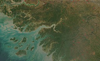
| Baare me | Satellite image of Guinea-Bissau in January 2003. |
| Taarik | |
| Source | Cropped from original: http://visibleearth.nasa.gov/view_rec.php?id=4841 |
| Likhe waala | Jacques Descloitres, MODIS Rapid Response Team, NASA/GSFC |
The Islands are known as Bijagos Archipelago, in English, Bissagos in portuguese, one of them, nearest to the coast towards the centre of the image, furthest to the East being Bolama
Licence ke baare me
| This file is in the public domain in the United States because it was solely created by NASA. NASA copyright policy states that "NASA material is not protected by copyright unless noted". (See Template:PD-USGov, NASA copyright policy page or JPL Image Use Policy.) | ||
 |
Warnings:
|
File ke itihaas
File ke dekhe khatir, jaise uu time dekhe me lagat rahaa, date/time pe click karo.
| Din/Time | Chhota chapa | Lambai aur chaurai | Sadasya | Tiprrin | |
|---|---|---|---|---|---|
| abhi waala | 13:47, 22 Disambar 2004 | | 1,361 × 833 (169 KB) | Hautala | {{PD-USGov-NASA}} Satellite image of Guinea-Bissau in January 2003. Cropped image, original taken from NASA's Visible Earth http://visibleearth.nasa.gov/cgi-bin/viewrecord?23921 |
File ke kaise kaam me lawa gais hae
Niche ke panna kaam me laae hai ii file ke:
Global file usage
Ii aur duusra wiki ii file ke use kare hai:
- af.wikipedia.org pe upyog
- ar.wikipedia.org pe upyog
- azb.wikipedia.org pe upyog
- ca.wikipedia.org pe upyog
- de.wikipedia.org pe upyog
- en.wikipedia.org pe upyog
- es.wikipedia.org pe upyog
- fa.wikipedia.org pe upyog
- fr.wikipedia.org pe upyog
- fy.wikipedia.org pe upyog
- hu.wiktionary.org pe upyog
- it.wikipedia.org pe upyog
- nl.wikipedia.org pe upyog
- or.wikipedia.org pe upyog
- pt.wikipedia.org pe upyog
- ru.wikipedia.org pe upyog
- simple.wikipedia.org pe upyog
- sq.wikibooks.org pe upyog
- uk.wikipedia.org pe upyog
- yi.wikipedia.org pe upyog