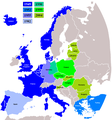
file:NATO expansion.png

Ii preview ke size: 720 × 600 pixels Duusra resolutions: 288 × 240 pixels | 576 × 480 pixels | 922 × 768 pixels | 1,200 × 1,000 pixels.
Original file (1,200 × 1,000 pixel, file ke size: 76 KB, MIME type: image/png)
File ke itihaas
File ke dekhe khatir, jaise uu time dekhe me lagat rahaa, date/time pe click karo.
| Din/Time | Chhota chapa | Lambai aur chaurai | Sadasya | Tiprrin | |
|---|---|---|---|---|---|
| abhi waala | 17:25, 3 Aprel 2018 |  | 1,200 × 1,000 (76 KB) | Maphobbyist | Reverted to version as of 09:42, 28 February 2009 (UTC) |
| 15:02, 3 Aprel 2018 |  | 1,280 × 979 (387 KB) | Maphobbyist | Update: Montenegro became a NATO member in 2017 | |
| 09:42, 28 Farwari 2009 |  | 1,200 × 1,000 (76 KB) | Turkish Flame~commonswiki | better map | |
| 14:39, 20 Disambar 2008 |  | 1,210 × 1,298 (91 KB) | IJA | + Gibraltar. Previously important British Military and Naval bases there, also we have included Spanish enclaves. | |
| 05:40, 5 Aprel 2008 |  | 1,210 × 1,298 (91 KB) | Hoshie | fixed Iceland, and the "r" in Turkey | |
| 05:29, 5 Aprel 2008 |  | 1,210 × 1,298 (90 KB) | Hoshie | removed anti-aliasing on country labels | |
| 07:19, 18 Julai 2007 |  | 1,210 × 1,298 (97 KB) | Hoshie | The Isle of Man is NOT in the UK! Fixed; under same lic. as original. | |
| 19:33, 25 Julai 2006 |  | 1,210 × 1,298 (97 KB) | Satesclop | +Ceuta and Melilla (in Spain) | |
| 15:24, 14 Julai 2006 |  | 1,210 × 1,298 (97 KB) | Kseferovic | This is the revised edition of the map that includes the Montenegro split from Serbia. (Also someone neglected to put the Bosnian coatline. | |
| 20:16, 25 Juun 2006 |  | 1,210 × 1,298 (103 KB) | Kseferovic | This is a revised edition of the map. It has Serbia and Montenegro divided. There are no coyrights. |
File ke kaise kaam me lawa gais hae
Ii file ke koi panna kaam me nai laae hai.
Global file usage
Ii aur duusra wiki ii file ke use kare hai:
- av.wikipedia.org pe upyog
- de.wikipedia.org pe upyog
- en.wikipedia.org pe upyog
- fr.wikipedia.org pe upyog
- ru.wikipedia.org pe upyog
- uk.wikipedia.org pe upyog


