
file:Location NATO 2009 blue.svg

Size of this PNG preview of this SVG file: 455 × 149 pixels. Duusra resolutions: 320 × 105 pixels | 640 × 210 pixels | 1,024 × 335 pixels | 1,280 × 419 pixels | 2,560 × 838 pixels.
Original file (SVG file, naam kare ke khatir 455 × 149 pixels, file size: 1.45 MB)
Sanchhipt me
| Baare me |
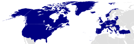
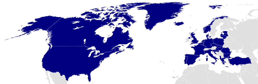
English: Member countries of NATO in blue Čeština: Členské státy NATO znázorněny modrou barvou. |
||
| Taarik | |||
| Source | Own work based on: Location NATO.svg by Ssolbergj | ||
| Likhe waala | Marco Kaiser | ||
| Adhikaar (Ii file ke fir se kaam me laawa jaae hai) |
I, the copyright holder of this work, hereby publish it under the following license: This file is licensed under the Creative Commons Attribution 3.0 Unported license.
|
||
| SVG genesis |
|
Original upload log
This image is a derivative work of the following images:
- Location NATO.svg licensed with Cc-by-3.0
- 2008-05-31T19:25:16Z Ssolbergj 616x247 (584395 Bytes) {{Information |Description= |Source= |Date= |Author= |Permission= |other_versions= }}
- 2008-05-31T19:22:41Z Ssolbergj 591x297 (584395 Bytes) {{Information |Description={{en|1=Member countries of NATO}} |Source=Own work by uploader |Author=[[:en:User:Ssolbergj|Ssolbergj]] |Date=31 May 2008 |Permission= |other_versions= }} [[Category:North Atla
Uploaded with derivativeFX
File ke itihaas
File ke dekhe khatir, jaise uu time dekhe me lagat rahaa, date/time pe click karo.
| Din/Time | Chhota chapa | Lambai aur chaurai | Sadasya | Tiprrin | |
|---|---|---|---|---|---|
| abhi waala | 10:39, 15 August 2022 | 455 × 149 (1.45 MB) | EmmaCoop | Reverted to version as of 05:51, 1 March 2015 (UTC); the map represents NATO as it existed in 2009 | |
| 14:06, 23 Julai 2022 | 455 × 149 (1.45 MB) | Kwamikagami | official UN blue, #009edb, update countries | ||
| 05:51, 1 Maach 2015 | 455 × 149 (1.45 MB) | Leftcry | Fix layout | ||
| 13:35, 2 Aprel 2009 | 616 × 247 (601 KB) | Marco Kaiser | Made Albania and Kroatia dark blue since they are Fullmembers of the NATO since 2009-04-01 | ||
| 10:05, 6 Farwari 2009 | 616 × 247 (599 KB) | Marco Kaiser | {{Information |Description={{en|1=Member countries of NATO in blue}} |Source=*File:Location_NATO.svg |Date=2009-02-06 10:04 (UTC) |Author=*File:Location_NATO.svg: Ssolbergj |Date=31 May 2008 *derivative work: ~~~ |Permis |
File ke kaise kaam me lawa gais hae
Ii file ke koi panna kaam me nai laae hai.
Global file usage
Ii aur duusra wiki ii file ke use kare hai:
- az.wikipedia.org pe upyog
- Türkiyə
- Gürcüstan
- Yunanıstan
- Bolqarıstan
- Almaniya
- Rumıniya
- Portuqaliya
- Macarıstan
- Norveç
- Latviya
- Lüksemburq
- İslandiya
- İspaniya
- İtaliya
- Xorvatiya
- Fransa
- Finlandiya
- Niderland
- Danimarka
- Estoniya
- Çexiya
- Albaniya
- Belçika
- Litva
- Slovakiya
- Sloveniya
- Polşa
- Şablon:NATO
- NATO
- Kanada
- Şimali Makedoniya
- Birləşmiş Krallıq
- Böyük Britaniya və Şimali İrlandiya Birləşmiş Krallığının dövlət və siyasi sistemi
- Norveç Krallığının hüquq sistemi
- ABŞ siyasi sistemi
- NATO üzvü olan ölkələr
- NATO sammiti
- Şimali Atlantik Şurası
- Sülh Naminə Tərəfdaşlıq
- Fərdi Tərəfdaşlıq üzrə Əməliyyat Planı
- İsveç–NATO münasibətləri
- bg.wikipedia.org pe upyog
- ckb.wikipedia.org pe upyog
Ii file ke more global usage kedekho.