
file:India Kerala Thiruvananthapuram district.svg

Size of this PNG preview of this SVG file: 411 × 599 pixels. Duusra resolutions: 164 × 240 pixels | 329 × 480 pixels | 527 × 768 pixels | 702 × 1,024 pixels | 1,405 × 2,048 pixels | 874 × 1,274 pixels.
Original file (SVG file, naam kare ke khatir 874 × 1,274 pixels, file size: 539 KB)
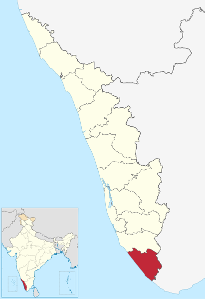
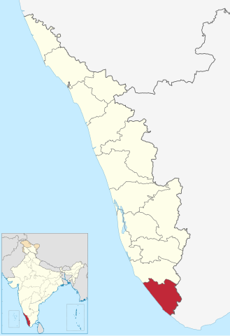
| Baare me | Location of Thiruvananthapuram district in Kerala |
| Taarik | (UTC) |
| Source | |
| Likhe waala |
|
I, the copyright holder of this work, hereby publish it under the following license:
ii file ke Creative Commons Attribution-Share Alike 3.0 Unported license ke niche licence karaa gais hai.
- You are free:
- share kare ke khaatir – to copy, distribute and transmit the work
- to remix – to adapt the work
- II condition ke niiche:
- attribution – Aap ke thiik credit de ke chaahi, licence pe jorr de ke chaahi, aur badlao ke dekhae ke chaahi. Aap iske koi reasonable manner me kare saktaa hai lekin aise nai ki lage ki licensor aap ke, nai to aap ke kaam ke endorse kre hai
- share alike – Agar aap milaata hai, badaltaa hai, nai to material pe jorrtaa hai, tab aap ke aapan yogdaan ke same or compatible license ke niche baate kare kae chaaahi.
Original upload log
This image is a derivative work of the following images:
- File:India_Kerala_location_map.svg licensed with Cc-by-sa-3.0
- 2011-03-11T09:30:07Z NordNordWest 827x1205 (135528 Bytes) =={{int:filedesc}}== {{Information |Description= {{de|Positionskarte von [[:de:Kerala|Kerala]], [[:de:Indien|Indien]]}} Quadratische Plattkarte, N-S-Streckung 102 %. Geographische Begrenzung der Karte: * N: 13.0° N * S: 8.0�
Uploaded with derivativeFX
File ke itihaas
File ke dekhe khatir, jaise uu time dekhe me lagat rahaa, date/time pe click karo.
| Din/Time | Chhota chapa | Lambai aur chaurai | Sadasya | Tiprrin | |
|---|---|---|---|---|---|
| abhi waala | 16:54, 10 Juun 2023 | | 874 × 1,274 (539 KB) | C1MM | updated bounds |
| 06:37, 4 Saptambar 2021 |  | 775 × 1,129 (507 KB) | C1MM | c bounds | |
| 11:21, 3 Aprel 2011 |  | 827 × 1,205 (72 KB) | BishkekRocks | fix | |
| 14:13, 11 Maach 2011 |  | 827 × 1,205 (76 KB) | BishkekRocks | {{Information |Description=Location of Thiruvananthapuram district in Kerala |Source=*File:India_Kerala_location_map.svg |Date=2011-03-11 14:09 (UTC) |Author=*File:India_Kerala_location_map.svg: {{U|NordNordWest}} *derivative work: ~~~ |Permis |
File ke kaise kaam me lawa gais hae
Niche ke panna kaam me laae hai ii file ke:
Global file usage
Ii aur duusra wiki ii file ke use kare hai:
- ar.wikipedia.org pe upyog
- arz.wikipedia.org pe upyog
- bn.wikipedia.org pe upyog
- ceb.wikipedia.org pe upyog
- de.wikipedia.org pe upyog
- en.wikipedia.org pe upyog
- Thiruvananthapuram
- Kovalam
- Attingal
- Neyyattinkara
- Varkala
- Nedumangad
- Kazhakoottam
- Amboori
- Thiruvananthapuram district
- Peroorkada
- Aakkulam
- Singarathoppe
- Vithura
- Sreekaryam
- Nemom
- Vizhinjam
- Thennoor
- Balaramapuram
- Nalanchira
- Karamana
- Poovar
- Aruvippuram
- Puthenthope
- East Fort
- Aryanadu
- Cherunniyoor
- Kaniyapuram
- Pallithura
- Navaikulam
- Pothencode
- Pakalkuri
- Kadinamkulam
- Kesavadasapuram
- Valiyavila
- Venganoor
- Chempazhanthy
- Bonacaud
- Tourism in Thiruvananthapuram
- Kunnathukal
- Moothala
- Karicharakadavu
- Thonnakkal
- Mandapathinkadavu
- Poojappura
Ii file ke more global usage kedekho.