
file:Bl-map.png
Aur achchha resolution nai hai.
Bl-map.png (327 × 350 pixel, file ke size: 12 KB, MIME type: image/png)

|
This locator map image could be re-created using vector graphics as an SVG file. This has several advantages; see Commons:Media for cleanup for more information. If an SVG form of this image is available, please upload it and afterwards replace this template with
{{vector version available|new image name}}.
It is recommended to name the SVG file “Bl-map.svg”—then the template Vector version available (or Vva) does not need the new image name parameter. |
Sanchhipt me
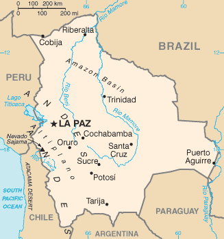
| Baare me | Bolivia map from CIA World Factbook (since 2 Juun 2004), converted from original GIF format |
| Taarik | |
| Source |
CIA World Factbook |
| Likhe waala | United States Central Intelligence Agency |
| Other versions |
Licence ke baare me
This image is in the public domain because it contains materials that originally came from the United States Central Intelligence Agency's World Factbook.
|
 |
Derivative works
-
 Bl-map mk.png
македонски -
 Bolivie carte.gif
français -
 Bolivyaharita.jpg
Türkçe -
 Ka Bolivia-Map.png
ქართული


File ke itihaas
File ke dekhe khatir, jaise uu time dekhe me lagat rahaa, date/time pe click karo.
| Din/Time | Chhota chapa | Lambai aur chaurai | Sadasya | Tiprrin | |
|---|---|---|---|---|---|
| abhi waala | 09:15, 17 Juun 2008 | | 327 × 350 (12 KB) | Sevela.p | Remove black line on the left side |
| 17:52, 27 Farwari 2005 |  | 328 × 350 (12 KB) | Alfio | CIA map of Bolivia |
File ke kaise kaam me lawa gais hae
Niche ke panna kaam me laae hai ii file ke:
Global file usage
Ii aur duusra wiki ii file ke use kare hai:
- af.wikipedia.org pe upyog
- ar.wikipedia.org pe upyog
- ast.wikipedia.org pe upyog
- ay.wikipedia.org pe upyog
- be.wikipedia.org pe upyog
- bn.wikipedia.org pe upyog
- bn.wikibooks.org pe upyog
- bo.wikipedia.org pe upyog
- ca.wikipedia.org pe upyog
- cs.wikipedia.org pe upyog
- da.wikipedia.org pe upyog
- de.wikibooks.org pe upyog
- de.wikinews.org pe upyog
- dsb.wikipedia.org pe upyog
- dz.wikipedia.org pe upyog
- el.wikipedia.org pe upyog
- en.wikipedia.org pe upyog
- List of islands of South America
- Talk:Geography of Bolivia
- Outline of Bolivia
- Irrigation in Bolivia
- Water resources management in Bolivia
- Agriculture in Bolivia
- Module:Location map/data/Bolivia/doc
- Module:Location map/data/Bolivia
- User:Gonzalezmwalter/Bolivia and the International Monetary Fund
- User:Gonzalezmwalter/IMF Bolivia
- Bolivia and the International Monetary Fund
- en.wikibooks.org pe upyog
- en.wikinews.org pe upyog
- en.wikisource.org pe upyog
- eo.wikipedia.org pe upyog
Ii file ke more global usage kedekho.